Authors: Pallavi Anantharam, Óscar Fernández & Brian Hannah
How does space technology help us with climate issues here on Earth? The use of space technology for disaster management as well as climate change-related issues continues to gain increasing attention around the world. Several national space organizations such as the European Space Agency (ESA) and Indian Space Research Organization (ISRO) are calling for an active increase in the use of satellites for disaster mitigation and recovery efforts.
This article will examine the impact of natural disasters such as floods, and their relation to climate change. In addition, we will briefly explore how space technologies may be implemented for routine use in the future to help reduce damage and loss of life due to floods.
Disasters in numbers
Unfortunately, climate change has been shown to increase the likelihood of floods and the potential severity of weather events. The Intergovernmental Panel on Climate Change (IPCC) found that climate change can increase precipitation through warmer atmospheres, increase snowmelt, and lead to more volatile storms. Floods are caused by a variety of factors, however, many of these factors are made more frequent or more severe through climate change.
According to Our World in Data (2021), natural disasters kill on average 60,000 people per year and are responsible for 0.1% of all deaths over the last decade. 60,000 per year is low compared to certain other causes of death like car accidents, which kill over 1 million people worldwide annually according to the CDC (Center for Disease Control). Yet, 60,000 is still too high, and floods are one of the main contributors to these 60,000 natural disaster-related deaths. About 1,600 people died in India between July and September 2019 due to flash flooding. In March, torrential rain forced more than 4,000 Indonesians out of their homes in the Papua province. Approximately 1000,000 people living in the Central African Republic were displaced by floods that destroyed their homes in 2019. Floods also heavily affected places such as Nepal, Myanmar, China, and Banglades
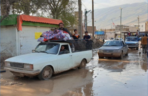
10 May 2019 – On 18 March 2019, Iran was ravaged by three waves of dangerous rain and flooding, affecting thousands of people in the west, southwest, and northeast provinces of Iran (WHO, 2021)
Space technology and climate change
Using space technology for earth observation and climate action is probably not the most well-known or publicized impact of our activities in space. Nevertheless, the alliance between space technology and climate action is only growing stronger. Today the importance of using space technology for climate action is reinforced through humanitarian policies such as the United Nations 2030 Agenda. The United Nations recognizes the useful cooperation that can exist between space technology and earth-based goals.
Companies today bring interesting contributions to the challenge of climate action. One example is Google, when in 2019, it announced the implementation of a flood forecasting model in the Patna region, in India. Google built an inundation model that can predict the water level rise in a particular area and assess the “water behavior,” or what areas can be flooded very quickly. Google has amassed an arsenal of high-quality elevation maps, thanks to satellite imagery. Google continues to work with satellite imaging partners to make sure their model has the imaging data necessary to predict climate events. Further advances in technologies such as AI and machine learning can strengthen our approach to prediction and mitigation.
Satellite imagery has also been used for rescue and disaster response. If the disaster has already taken place, we can utilize technology thousands of miles above us to better target relief and rescue efforts. One computer scientist used machine learning and satellite imagery to automatically detect flooded roads. The accurate and real-time imagery that we are now able to get from satellites gives innovative minds here on Earth a useful ingredient when building climate action tools.
Like the models that Google or an individual programmer have created, other applications can help monitor sea levels and other bodies of water and alert populations of alarming changes. We can monitor long-term trends that may help a region better prepare for future disasters or track daily changes to help our disaster response and damage mitigation. The satellites above our atmosphere can act as guardians against natural disasters that are unfortunately increasing in frequency and severity due to climate change.
The use of space technologies to face the global challenge of climate disasters and climate change is one we cannot afford to ignore. We must utilize space technology such as satellite imaging, and work to make sure that other emerging technologies such as Machine Learning, AI, and Blockchain, can help space technology make meaningful impacts in our fight against climate change.


