Can satellites end vulnerability to natural disasters?
Accelerated technological convergence and dedicated information sharing mechanisms have made satellite technology an indispensable asset to developing countries. Far from being a luxury, earth observation missions spearheaded by various space agencies have demonstrated immediate benefits for populations most vulnerable to natural disasters.
Authors: Jean Lévy, Niki Sajjad
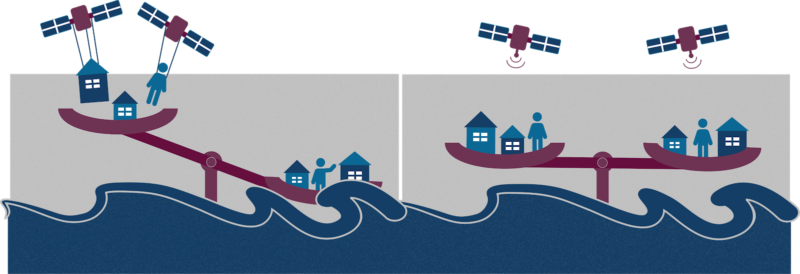
Consider two fictional countries: one is in development, while the other is developed. Both are coastal countries near a continental fault, which they know is a natural hazard. One day, an underwater earthquake leads to a tsunami. Despite being exposed to the same hazard, both countries will face very different outcomes. Reflecting their respective economic capabilities, these countries will have different degrees of preparation, including data on the continental fault and the populations and areas most at risk.
Inequalities create vulnerability
There is an inequality between developed countries and developing countries in their ability to prevent and respond to natural disasters. According to a 2006 OECD report, this difference in ability is what constitutes vulnerability. Climate change compounds this inequality by making natural disasters both more frequent and more intense, upending development with heavy economic and human consequences and increasing the vulnerability of developing countries. In contrast, developed countries, like Japan, that have high exposure to natural disasters have invested in specialised infrastructure and early warning systems, making them less vulnerable.
The United Nations Sustainable Development Goal number 10 (SDG 10) is to reduce inequalities, in part through better wealth distribution and increased democratic participation. The populations that SDG 10 aims to help are also those most disenfranchised and most vulnerable to natural disasters: they are isolated geographically, with little savings to rely on, have precarious living conditions and fragile sources of income, which makes it even harder for development policies to reach them.
The shared aspects between vulnerability to natural disasters and economic and political disenfranchisement means that actions can be taken to address both at once and break the vicious circle.
From eyes in the sky…
Because SDG 10 and long-term disaster management rely so heavily on policy making, it is crucial that lawmakers are able to rely on accurate information to help the people in need. In this capacity, satellite technology and Earth Observation (EO) stand out in the toolbox of technology available to governments, NGOs and international organisations by the impact they make.
Starting with the launch of TIROS-1 by NASA in 1960, specialised EO missions, satellites whose mission is to observe and record various data of the earth, have been deployed for the purpose of alleviating the impact of natural disasters. Since then, meteorological science and satellite technology have further converged, resulting in the development of highly specialised technology.
The Pléiades satellites for instance, were developed by the CNES to offer fine control and state-of-the-art instruments that allow them to quickly reposition and collect data on ongoing disasters. They are part of a growing collection of purpose-built satellites now operating in the upper fringes of earth’s atmosphere that are able to provide overlapping, global, real-time data for policymakers.
More importantly, the data collected by these satellites has been made publicly accessible by its owners: NASA’s Landsat missions and the ESA’s Copernicus program both share their observations openly and for free.
The use of specialised satellite technology has allowed countries to collect better information on areas and populations affected by disasters. In turn, this has allowed relief organisations and governments to react faster, with more accuracy to in-progress disasters and to give warnings with larger lead times on impending disasters.
…To boots on the ground
To facilitate the flow of actionable data to decision makers, information sharing mechanisms like the International Charter on Space and Major Disasters have created streamlined circuits from the eye-in-the-sky to the boots-on-the-ground end users. The charter counts over 30 members and partners that share data with disaster relief organisations to confront anything from fires to earthquakes and floods1.
Another example of cooperation is the European operational satellite agency for weather, climate and environment monitoring, EUMETSAT2. This agency shares uninterrupted observation data with the African Development Bank (AfDB), which enables it to help implement the Satellite and Weather Information for Disaster Resilience in Africa (SAWIDRA).
A 2020 study by the Kenya Red Cross Society (KRCS) on the end of year mudslides in the West Pokot region of Kenya found that satellite imagery and international partnerships had allowed the KRCS to provide targeted assistance to affected areas. Using the Pléiades satellites, the partnership between the Airbus Foundation and International Centre for Humanitarian Affairs (ICHA), KRCS were able to identify houses and roads most affected by comparing new and archived satellite imagery3.
This EO capacity is often combined with other data, such as poverty maps, to plan ahead of recurring natural disasters and mitigate their impact on affected populations. Mongolia’s unique combination of summertime droughts and harsh winters, a phenomenon called dzud, has affected the poorest herders by killing their animals every year. In addition to being one of the most vulnerable to climate change, nearly one third of Mongolia’s population relies on pastoral farming4. Thanks to a partnership between international, regional and national organisations, the DroughtWatch program has enabled Mongolia to identify precursor signs of droughts and design better responses to protect livestock and livelihoods5.
DroughWatch is a pilot in the Regional Collaborative Mechanisms on Drought Monitoring and Early Warning program launched by the United Nations Economic and Social Commission for Asia and the Pacific (UNESCAP) to provide data, training and products to governments of countries prone to droughts articulated around a Chinese service node. As a pioneering program, DroughtWatch has focused on building its database, data monitoring and processing methods as well as academic and professional formation to be able to utilise EO tools effectively.
Who does the tech work for?
First deployed by developed countries, satellite technology has become crucial in helping to combat unequal vulnerability to natural disasters and protecting development efforts. Both practically and symbolically, this deliberate use of technology by multilateral, international organisations shows that technology properly framed in a cooperative setting can meet the challenges of sustainable development.
The buildup of technological capability, as well as the creation of international information sharing practices through EO to address natural disasters also has long term implications for developing countries.
On the one hand, the protection afforded by satellites against natural disasters will give more time for development policies to take effect and facilitate the deployment of information and communication technologies (ICT) that developed economies rely on. Investment into ICTs has been known to enable access to information and technologies that combat revenue gaps, such as India’s Digital Aadhaar6.
On the other hand, the integration of developing countries in the design and operation of EO missions reduces the technological gaps between developed and developing countries. For example, UNESCAP’s endeavour to provide advanced drought warning through the Regional Cooperative Mechanism for Drought Monitoring and Early-Warning has managed to integrate multiple regional agencies to maximise the benefit to the governmental end users and build-up local capacity.
This ensures the application of these new technologies responds to the needs of the most vulnerable and enables the sharing of critical skills and know-how for developing countries that seek to adopt other ICT-based technologies.
Conclusion
Space technology, in the guise of Earth Observation missions, has become a vector for combating salient inequalities by enabling developing countries to plan ahead of disasters. This combination of data analysis and international cooperation empowers them to protect the livelihoods of their populations and create long-term economic and educational opportunities. Disproving the idea that space technology is a luxury and a symbol of economic disparity, EO missions have proved their worth in meeting the needs of the most vulnerable.
1 https://disasterscharter.org/web/guest/home;jsessionid=25688E98E783909EBD5A94AD731761F9.APP1
2 https://www.eumetsat.int/africa/cooperation-african-institutions
3 https://reliefweb.int/sites/reliefweb.int/files/resources/Case%20Study%20-%20Use%20of%20earth%20observation%20products%20to%20enhance%20humanitarian%20disaster%20response%20West%20Pokot.pdf
4 https://www.un-spider.org/news-and-events/news/satellite-based-system-monitor-droughtsdzuds-handed-over-mongolia
5 UNESCAP, Mongolia’s National Remote Sensing Centre (NRSC), the Information and Research Institute of Meteorology, Hydrology and Environment (IRIMHE), technical support of RAD (https://reliefweb.int/report/mongolia/satellite-based-system-monitor-droughtsdzuds-handed-over-mongolia#:~:text=DroughtWatch%2DMongolia%20is%20a%20system,and%20mitigation%20departments%20in%20Mongolia.&text=
Thus%2C%20Mongolia’s%20capacity%20to%20monitor,%2C%20dzud%2C%20has%20been%20enhanced.)
6 https://artnet.unescap.org/sti/publications/books-reports/technology-and-inequalities-ch4-inequality-asia-and-pacific-era-2030
Sources:
| Kavanagh, Jack. 2018. “Satellite-Based System to Monitor Droughts/Dzuds Handed over to Mongolia,” 2018. https://www.un-spider.org/news-and-events/news/satellite-based-system-monitor-droughtsdzuds-handed-over-mongolia. | |
| Osunga, Michael, Betty Makena, and Halima Saado Abdillahi. 2020. “Use of Earth Observation Products to Enhance Humanitarian Disaster Response, A Case Study of KRCS Response to West Pokot Mudslides in 2019.” https://reliefweb.int/sites/reliefweb.int/files/resources/Case Study – Use of earth observation products to enhance humanitarian disaster response West Pokot.pdf. | |
| Dayton-Johnson, Jeff. 2006. “POLICY BRIEF No. 29 Natural Disaster and Vulnerability.” https://www.oecd.org/dev/37860801.pdf. | |
| “Technology and Inequalities (Ch4 in Inequality in Asia and the Pacific in the Era of the 2030 Agenda for Sustainable Development).” 2018. | |
| Cozannet, G. Le, M. Kervyn, S. Russo, C. Ifejika Speranza, P. Ferrier, M. Foumelis, T. Lopez, and H. Modaressi. 2020. “Space‐Based Earth Observations for Disaster Risk Management.” Survey in Geophysics. | |
| Petiteville, Ivan, Stephen Ward, George Dyke, Matthew Stevenson, and Jennifer Harry. 2015. “SATELLITE EARTH OBSERVATIONS IN SUPPORT OF DISASTER RISK REDUCTION.” | |
| Wu, Bingfang. 2018. “DroughtWatch for Mongolia under Regional Cooperative Mechanism: Experiences and Lessons.” https://www.unescap.org/sites/default/files/02_Bingfang Wu_DroughtWatch for Mongolia under regional cooperation mechanism.pdf. | |

